The great parks: From Las Vegas and back
When to go
April to May and late September to October. In June, July and August Las Vegas, Valley of Fire and the bottom of the canyons pass forty degrees, and from July to September the summer monsoon brings afternoon storms and flash floods that close the Narrows and the slot canyons. Bryce and the South Rim of the Grand Canyon stand above two thousand metres, so nights there are cold even in summer, and from November to March snow can close their roads for a day.
The stops
Interactive map of the route on our site ›
- Las Vegas2 nights
Most of the Strip lies outside the city of Las Vegas, in the unincorporated town of Paradise. One of its first great resort-casinos, the Flamingo, was opened in 1946 by the Jewish gangster Bugsy Siegel, who was shot dead in Beverly Hills six months later.
- Valley of Firestop on the way
Nevada’s oldest state park, dedicated in 1935, a maze of red sandstone that seems to burn in the low sun. At Atlatl Rock a stairway climbs to petroglyphs carved by the people who lived here two thousand years ago and more.
- Overton NVone night
A farming village in the Moapa Valley, at the north end of Lake Mead. Its Lost City Museum was built in the 1930s by the Civilian Conservation Corps to keep what was dug up at Pueblo Grande de Nevada, a string of Ancestral Puebloan villages along the Muddy River that the waters of the lake later covered.
- St. Georgestop on the way
A town founded by Mormon settlers in 1861, sent to grow cotton in the warm valley, which is why the area is still called Utah’s Dixie. The white St. George Temple, dedicated in 1877, was the first Mormon temple completed in Utah, and Brigham Young spent his last winters in a house a few streets away.
- Springdale3 nights
The small town at the gate of Zion, the first national park in Utah, established in 1919. The Mormon pioneer Isaac Behunin, who farmed in the canyon in the 1860s, is said to have named it Zion, a place of peace and refuge.
- Angels Landingstop on the way
A fin of rock some 450 metres above the canyon floor, reached by switchbacks called Walter’s Wiggles and then a last stretch of some eight hundred metres along a narrow ridge with chains to hold. Since 2022 the final section needs a permit drawn by lottery; without one, Scout Lookout below it is open to all.
- The Narrowsstop on the way
At the end of the canyon road the walls close in and the trail becomes the Virgin River itself; you walk upstream in the water between cliffs hundreds of metres high, as far as you like. The park closes it when the flow is high, and the danger is a flash flood from a storm far upstream.
- Zion–Mount Carmel Tunnelstop on the way
Finished in 1930, the tunnel runs some 1.8 kilometres through the sandstone, with galleries cut in its wall that look out over the canyon. It is too narrow for large vehicles to pass each other, so rangers stop the traffic for them and charge a fee for the escort.
- Bryce Canyon Cityone night
A town that is almost a single family business: Reuben Syrett opened a lodge here in 1916, on the edge of what became the national park, and Ruby’s Inn grew into the hotel, store and rodeo arena around which the town was incorporated in 2007.
- Bryce Canyonstop on the way
Not a canyon but a row of amphitheatres cut into the edge of a plateau, filled with thousands of orange stone spires called hoodoos. It is named for Ebenezer Bryce, a Mormon settler of the 1870s, who is remembered for calling it a hell of a place to lose a cow.
- Red Canyonstop on the way
Hoodoos of a deeper red than those of Bryce, right beside Route 12, where the road passes through two arches cut in the rock. The outlaw Butch Cassidy grew up in Circleville, not far to the north, and a trail here carries his name.
- Kanabone night
From the 1920s onward Hollywood came here to film westerns among the red cliffs, and the town still calls itself Little Hollywood; the stars stayed at Parry Lodge on the main street. Just north of town is Best Friends, the largest no-kill animal sanctuary in the United States.
- Lake Powell and Glen Canyon Damstop on the way
The dam, finished in the 1960s, drowned Glen Canyon on the Colorado and made Lake Powell, one of the two largest reservoirs in the country, named after John Wesley Powell, the one-armed major who first ran the river in 1869. In the drought years its water has fallen far, leaving white rings on the red cliffs.
- Page2 nights
A town founded in 1957 as the camp for the workers who built Glen Canyon Dam, on land the government received from the Navajo Nation in exchange for land in Utah. It is named after John C. Page, a commissioner of the Bureau of Reclamation that built the dam.
- Antelope Canyonstop on the way
A slot canyon on Navajo land, carved by flash floods into curving walls of sandstone that glow when the sun shines down into them. It can be entered only on a tour with a Navajo guide; in August 1997 a flash flood in the lower canyon killed eleven hikers.
- Horseshoe Bendstop on the way
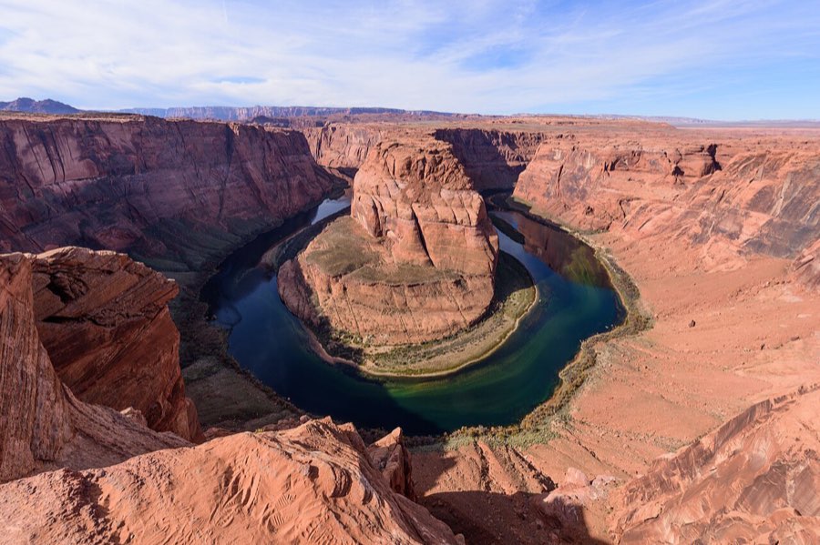
The Colorado swings almost all the way around a sandstone butte here, some three hundred metres below the rim. A sandy path of about two kilometres there and back leads from the car park; the edge has a railing only at the main viewpoint, and the light is best late in the afternoon.
- Cameron AZone night
A trading post on the Navajo Nation above the Little Colorado River, opened in 1916 by the brothers Hubert and C. D. Richardson beside a suspension bridge of 1911 that still stands. It keeps a hotel, a restaurant that serves Navajo tacos on fry bread, and a gallery of Navajo rugs.
- Little Colorado River Gorgestop on the way
A tribal park of the Navajo Nation, where the Little Colorado has cut a sheer gorge into the plateau on its way to the Grand Canyon. Downstream, near its end, the river turns turquoise from the minerals of Blue Spring, which feeds it all year.
- Desert View Watchtowerstop on the way
The eastern gate of the South Rim, where the Desert View Drive begins its run of about forty kilometres along the edge. The stone tower was designed by the architect Mary Colter and finished in 1932, with murals inside by the Hopi painter Fred Kabotie.
- Grand Canyon, Mather Pointstop on the way
The first great view for most visitors, beside the main visitor centre; the canyon below is about a mile, some 1,600 metres, deep. The point is named after Stephen Mather, the first director of the National Park Service, and the Grand Canyon became a national park in 1919.
- Grand Canyon Villageone night
The village on the South Rim grew around the railway that reached it from Williams in 1901. El Tovar, the hotel on the rim, opened in 1905, and beside it Mary Colter built Hopi House, a copy of a Hopi pueblo, to sell Native crafts; the Bright Angel Trail starts a few steps away.
- Flagstaff2 nights
A mountain town of pine forest at some 2,100 metres. At Lowell Observatory on the hill above it, Clyde Tombaugh found Pluto in 1930, and in 2001 Flagstaff became the first International Dark Sky City, with street lights shaded to keep the stars visible.
- Sedonastop on the way
Red sandstone towers around a town reached from Flagstaff by the switchbacks of Oak Creek Canyon. The Chapel of the Holy Cross, built in 1956, rises straight out of the red rock, and the trailheads need a Red Rock Pass for parking.
- Williamsstop on the way
The last town on Route 66 to be bypassed by Interstate 40, in October 1984. It is also the station of the Grand Canyon Railway, which has carried passengers to the South Rim since 1901, with a gap from 1968 to 1989.
- Seligman AZone night
A village on old Route 66 that nearly died when Interstate 40 bypassed it in 1978. Its barber, Angel Delgadillo, led the founding of the Historic Route 66 Association of Arizona in 1987, which got the old road its historic signs and brought the travellers back; the makers of the film Cars came here while researching it.
- Hackberry General Storestop on the way
A lonely store on the longest surviving stretch of old Route 66, which runs some 250 kilometres from Seligman to Topock. Bob Waldmire, the artist who travelled the road in a Volkswagen bus, revived the store in 1992, and he was the model for Fillmore, the hippie van of the film Cars.
- Kingman AZone night
A railway town on Route 66, whose Powerhouse, built in the first years of the twentieth century to supply electricity to the mines of the region, now holds the Arizona Route 66 Museum. Clark Gable and Carole Lombard were married in the Methodist church here in March 1939.
- Hoover Damstop on the way
A concrete arch dam about 220 metres high on the Colorado, dedicated in 1935, which holds back Lake Mead. It straddles the border of Nevada and Arizona, and in winter, when Nevada is an hour behind, the clocks on its two intake towers show different times.
- Boulder Cityone night
Built by the government in 1931 to house the workers of Hoover Dam, it sold no alcohol until 1969 and is still one of only two towns in Nevada where gambling is banned. The Boulder Dam Hotel of 1933 holds a museum of the dam and of the men who built it.
- Las Vegasone night
The city exists because of the water: the springs in its valley gave it the Spanish name for the meadows, and Hoover Dam later gave it the power and water to grow in the desert. The Neon Museum keeps the old signs of the Strip’s demolished hotels in a lot known as the Neon Boneyard.
What it costs
Eighty dollars a night is the room. The car, the fuel and the park fees are yours; there are no toll roads on the way. The national parks charge per car, and the annual America the Beautiful pass covers Zion, Bryce, Glen Canyon and the Grand Canyon in one card; since 2026 visitors from abroad pay more for it than Americans, and the busiest parks add a fee for foreigners who come without it, so on this route it pays for itself. It does not cover Valley of Fire, which is a state park, the Navajo tour of Antelope Canyon, booked ahead and paid separately, or the parking at Horseshoe Bend. The car goes back to Las Vegas, so there is no one-way charge.
What to know
Three things. One: the heat. In summer carry far more water than you think, at least four litres a person for a day on the trails, hike before ten in the morning, and never leave anyone in a parked car; at Valley of Fire and in the canyons heat kills visitors almost every year. Two: Zion. For most of the year private cars may not drive the main canyon road, and a free park shuttle runs from the visitor centre; in high season be in line early, and park in Springdale and take the town shuttle in. Angels Landing needs a permit won in an online lottery, and the Narrows close when the river runs high. Three: the clocks. Nevada is on Pacific time and Utah on Mountain time, both with summer time; Arizona keeps Mountain time all year without summer time, but the Navajo Nation, inside Arizona, does change its clocks. In summer the hour in Page and in Antelope Canyon can differ, so check which time your tour is booked in.
Roads, tolls and rules
The United States drives on the right, and distances and speeds are in miles. The roads are wide and empty, but the towns are far apart: fill up whenever the tank is half empty, and keep to daylight, because deer, elk and cattle stand on the road at dusk. The days are kept to about 160 kilometres or less, with a night in a small town between the parks. The one longer day is the remote stretch from Overton to Zion, about 195 kilometres with a single stop in St. George. The route was meant to end in Los Angeles, but from Flagstaff that is some 750 kilometres, so it turns back instead along old Route 66 and over Hoover Dam to Las Vegas, over three short days with nights in Seligman, Kingman and Boulder City. From Las Vegas, Los Angeles is about four hours on the I-15 for anyone who wants to fly home from there.
Travel The great parks: From Las Vegas and back
The route on our site, with a room up to $80 every night.