Queensland: From Cairns to the rainforest
When to go
May to October, the dry season: warm and sunny days, low humidity, calm seas for the reef boats, and fewer stingers in the water. From December to April is the wet season, with heavy tropical rain, high humidity and the risk of cyclones; creeks flood across the road north of the Daintree and some tours stop. The stinger season, when dangerous jellyfish are in the sea, runs from about November to May.
The stops
Interactive map of the route on our site ›
- Cairns2 nights
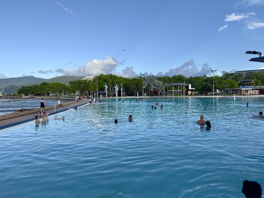
Founded in 1876 as a port for the goldfield on the Hodgkinson River, and named after the governor of Queensland, William Wellington Cairns. The shore in front of the city is tidal mudflat, not beach, so the city built the Esplanade Lagoon, a free saltwater pool on the seafront.
- Green Islandstop on the way
A coral cay with its own rainforest, inside the Great Barrier Reef, a World Heritage site since 1981 that runs for more than 2,300 kilometres. James Cook named the island in 1770 after Charles Green, the astronomer aboard the Endeavour.
- Barron Fallsstop on the way
Falls where the Barron River drops off the edge of the tablelands into its gorge. Since the 1930s a hydro-electric station has taken much of the water, so they are a trickle in the dry season and a roaring flood after the summer rains.
- Kurandastop on the way
A village in the rainforest above the Barron Gorge. The Kuranda Scenic Railway, built between 1882 and 1891, climbs to it from Cairns through fifteen hand-dug tunnels, and since 1995 the Skyrail cableway has run some seven and a half kilometres over the canopy.
- Curtain Fig Treestop on the way
A strangler fig on the Atherton Tablelands near Yungaburra. It grew down around a host tree, which then fell against a neighbour, and the fig’s aerial roots dropped from the leaning trunk to the ground in a curtain many metres high.
- Yungaburraone night
A heritage village on the Atherton Tablelands, cool after the coast. From the viewing platform on Peterson Creek, at the edge of the village, wild platypus can often be seen at dawn and dusk.
- Lake Eachamstop on the way
A crater lake in an old volcanic vent, ringed by rainforest, with no stream flowing in or out; it is filled by rain and groundwater. A walk of about three kilometres circles it, and people swim off the edge.
- Mareebastop on the way
A farming town on the dry side of the tablelands, where irrigation grows mangoes, avocados and coffee; most of the coffee grown in Australia comes from around here, and several plantations open for tastings.
- Mossman Gorgestop on the way
A river of granite boulders in the southern Daintree, in the country of the Eastern Kuku Yalanji people. Cars stop at the Mossman Gorge Centre, a shuttle bus runs into the gorge, and Kuku Yalanji guides lead walks through the forest.
- Port Douglasone night
Founded in 1877 as a rival port for the same goldfield, it lost the trade to Cairns and stayed a fishing village until the resorts came in the 1980s. The boats to the outer reef and to the Low Isles leave from its marina, and Four Mile Beach runs south of the town.
- Daintree River Ferrystop on the way
A cable ferry that pulls itself across the river on steel cables, the only way over. There is no bridge, and many who live north of the river want it that way, to keep the forest beyond it as it is; look out for crocodiles on the mud banks.
- Mount Alexandra Lookoutstop on the way
A lookout on the forest road north of the ferry, over the mouth of the Daintree River, the mangroves and the sea, with Snapper Island offshore.
- Cape Tribulationone night
James Cook named it in June 1770, writing that here began all his troubles: that night the Endeavour struck the reef offshore and had to be beached for repairs further north, where Cooktown now stands. Here the Daintree rainforest, part of the Wet Tropics World Heritage site, comes down to meet the reef, two World Heritage sites side by side.
- Hartley's Crocodile Adventuresstop on the way
A crocodile farm and wildlife park on the Captain Cook Highway, with a boat cruise on its lagoon where saltwater crocodiles leap from the water for food. It is the safe way to see the animal this coast warns you about.
- Palm Covestop on the way
A beach village of the northern beaches, its esplanade shaded by old paperbark trees. In the stinger season a net encloses a swimming area off the patrolled beach.
- Cairnsone night
The tidal flats along the Esplanade are a feeding ground of international importance for migrating shorebirds, which fly in each spring from as far as Siberia and northern China. Walk the boardwalk at low tide with binoculars.
What it costs
Eighty dollars a night is the room. The car and the fuel are yours, and there are no toll roads in the far north of Queensland. The route starts and ends in Cairns, so there is no one-way fee. The extras to budget are the Daintree River ferry, paid per car for each crossing, and the trips themselves: the reef boat, priced per person with the reef charge included, and the Kuranda railway or the Skyrail cableway, if you take them instead of the drive.
What to know
Three things. One: the water. From about November to May box jellyfish and the tiny Irukandji drift along this coast, and a sting can kill; swim only inside the stinger nets at patrolled beaches, and on the reef wear the stinger suit the boat lends you. And saltwater crocodiles live in every river, creek and mangrove here, and on the beaches too: never swim in a river or a creek, keep well back from the water’s edge, and obey every warning sign. Two: the Daintree. The river has no bridge, only a cable ferry, and beyond it the sealed road to Cape Tribulation is narrow and winding, with speed humps where cassowaries cross; a two-wheel-drive car is fine as far as Cape Tribulation. North of it the Bloomfield Track is for four-by-fours only, and rental contracts forbid it. Three: the wet season. Rain closes creek crossings within hours; check the road before you drive north.
Roads, tolls and rules
Australia drives on the left. The route climbs first from Cairns up the range to Kuranda and the cool Atherton Tablelands for a night, then comes down by Mareeba and the Rex Range to Mossman and Port Douglas. Beyond Mossman the road crosses the Daintree River by ferry and winds on through the forest to Cape Tribulation; there is little mobile coverage and little fuel, so fill up in Mossman. The way back to Cairns is the Captain Cook Highway, squeezed between the rainforest hills and the sea. No day is longer than about 160 kilometres.
Travel Queensland: From Cairns to the rainforest
The route on our site, with a room up to $80 every night.